


News
Cultural sites in Africa, Arab Region, Asia, Europe, and Latin America inscribed on UNESCO’s World Heritage List
Date:2021-07-28
The World Heritage Committee today added 13 cultural sites to UNESCO’s World Heritage List and one extension to an existing cultural site in Mexico. Roșia Montană Mining Landscape (Romania), was simultaneously inscribed on the List of World Heritage in Danger pending the removal of threats to its integrity posed by possible extractive activities.
These additions were made during the extended 44th session of the World Heritage Committee held online and chaired from Fuzhou (China), which is examining nominations from both 2020 and 2021. The inscription of sites on UNESCO’s World Heritage List is scheduled to continue through 28 July.
Brief descriptions of the newly inscribed sites:
India, Dholavira: a Harappan City
The ancient city of Dholavira, the southern centre of the Harappan Civilization, is sited on the arid island of Khadir in the State of Gujarat. Occupied between ca. 3000-1500 BCE, the archaeological site, one of the best preserved urban settlements from the period in Southeast Asia, comprises a fortified city and a cemetery. Two seasonal streams provided water, a scarce resource in the region, to the walled city which comprises a heavily fortified castle and ceremonial ground as well as streets and houses of different proportion quality which testify to a stratified social order. A sophisticated water management system demonstrates the ingenuity of the Dholavira people in their struggle to survive and thrive in a harsh environment. The site includes a large cemetery with cenotaphs of six types testifying to the Harappan’s unique view of death. Bead processing workshops and artifacts of various kinds such as copper, shell, stone, jewellery of semi-precious stones, terracotta, gold, ivory and other materials have been found during archaeological excavations of the site, exhibiting the culture’s artistic and technological achievements. Evidence for inter-regional trade with other Harappan cities, as well as with cities in the Mesopotamia region and the Oman peninsula have also been discovered.
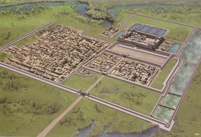
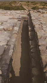
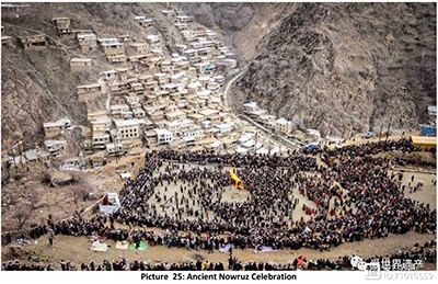
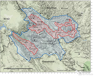
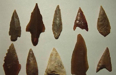
Iran (Islamic Republic of), Cultural Landscape of Hawraman/Uramanat
The remote and mountainous landscape of Hawraman/Uramanat bears testimony to the traditional culture of the Hawrami people, an agropastoral Kurdish tribe that has inhabited the region since about 3000 BCE. The property, at the heart of the Zagros Mountains in the provinces of Kurdistan and Kermanshah along the western border of Iran, encompasses two components: the Central-Eastern Valley (Zhaverud and Takht, in Kurdistan Province); and the Western Valley (Lahun, in Kermanshah Province). The mode of human habitation in these two valleys has been adapted over millennia to the rough mountainous environment. Tiered steep-slope planning and architecture, gardening on dry-stone terraces, livestock breeding, and seasonal vertical migration are among the distinctive features of the local culture and life of the semi-nomadic Hawrami people who dwell in lowlands and highlands during different seasons of each year. Their uninterrupted presence in the landscape, which is also characterized by exceptional biodiversity and endemism, is evidenced by stone tools, caves and rock shelters, mounds, remnants of permanent and temporary settlement sites, and workshops, cemeteries, roads, villages, castles, and more. The 12 villages included in the property illustrate the Hawrami people’s evolving responses to the scarcity of productive land in their mountainous environment through the millennia.
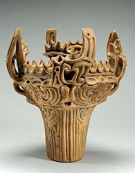
Japan, Jomon Prehistoric Sites in Northern Japan
The property consists of 17 archaeological sites in the southern part of Hokkaido Island and northern Tohoku in geographical settings ranging from mountains and hills to plains and lowlands, from inland bays to lakes, and rivers. They bear a unique testimony to the development over some 10,000 years of the pre-agricultural yet sedentary Jomon culture and its complex spiritual belief system and rituals. It attests to the emergence, development, maturity and adaptability to environmental changes of a sedentary hunter-fisher-gatherer society which developed from about 13,000 BCE. Expressions of Jomon spirituality were given tangible form in objects such as lacquered pots, clay tablets with the impression of feet, the famous goggle eyed dogu figurines, as well as in ritual places including earthworks and large stone circles reaching diameters of more than 50 metres. The serial property testifies to the rare and very early development of pre-agricultural sedentism from emergence to maturity.
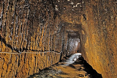
Romania, Rosia MontanăMining Landscape
Located in the Metalliferous range of the Apuseni Mountains in the west of Romania, Roșia Montană features the most significant, extensive and technically diverse underground Roman gold mining complex known at the time of inscription. As Alburnus Maior, it was the site of extensive gold-mining during the Roman Empire. Over 166 years starting in 106 CE, the Romans extracted some 500 tonnes of gold from the site developing highly engineered works, different types of galleries totalling 7km and a number of waterwheels in four underground localities chosen for their high-grade ore. Wax‐coated wooden writing tablets have provided detailed legal, socio‐economic, demographic and linguistic information about the Roman mining activities, not just in Alburnus Maior but also across the wider Dacian province. The site demonstrates a fusion of imported Roman mining technology with locally developed techniques, unknown elsewhere from such an early era. Mining on the site was also carried out, albeit to a lesser extent, between medieval times and the modern era. The later extractive works surround and cut across the Roman galleries. The ensemble is set in an agro-pastoral landscape which largely reflects the structures of the communities that supported the mines between the 18th and early 20th centuries. The site was also inscribed on the List of World Heritage in Danger due to threats posed by plans to resume mining which would damage a major part of the inscribed Mining Landscape.

Jordan, As-Salt - The Place of Tolerance and Urban Hospitality
Built on three closely-spaced hills in the Balqa highland of west-central Jordan, the city of As-Salt, was an important trading link between the eastern desert and the west. During the last 60 years of the Ottoman period, the region prospered from the arrival and settlement of merchants from Nablus, Syria, and Lebanon who made their fortunes in trade, banking, and farming. This prosperity attracted skilled craftsmen from different parts of the region who worked on transforming the modest rural settlement into a thriving town with a distinctive layout and an architecture characterized by large public buildings and family residences constructed of local yellow limestone. The site’s urban core includes approximately 650 significant historic buildings exhibiting a blend of European Art Nouveau and Neo-Colonial styles combined with local traditions. The city’s non-segregated development expresses tolerance between Muslims and Christians who developed traditions of hospitality evidenced in Madafas (guest houses, known as Dawaween) and the social welfare system known as Takaful Ijtimai’. These tangible and intangible aspects emerged through a melding of rural traditions and bourgeois merchants’ and tradespeople’s practices during the Golden Age of As-Salt’s development between 1860s to 1920s.

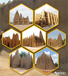
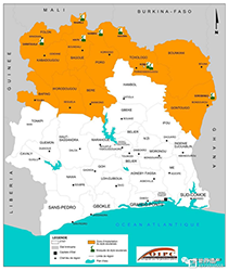
Côte d'Ivoire, Sudanese style mosques in northern Côte d’Ivoire
The eight small adobe mosques, at Tengréla, Kouto, Sorobango, Samatiguila, M’Bengué, Kong and Kaouara are characterized by protruding timbers, vertical buttresses crowned by pottery or ostrich eggs, and tapering minarets. They present an interpretation of an architectural style thought to have originated around the 14th century in the town of Djenné, then part of the Empire of Mali, which prospered from the trade in gold and salt across the Sahara to North Africa. Particularly from the 16th century, the style spread south from the desert regions into the Sudanese savannah, becoming lower and developing stouter buttresses in response to the wetter climate. The mosques are the best conserved of 20 such edifices that remain in Côte d’Ivoire, where hundreds existed early last century. The mosques’ distinctive Sudanese style, specific to the savannah region of West Africa, developed between the 17th and 19th centuries as traders and scholars spread south from the Empire of Mali, extending the trans-Saharan mercantile routes into the forest area. They present highly important testimonies to the trans-Saharan trade that facilitated the expansion of Islam and Islamic culture and reflect a fusion of Islamic and local architectural forms in a highly distinctive style that has persisted over time.
France, Nice, Winter Resort Town of the Riviera
The Mediterranean city Nice, near the Italian border, bears witness to the evolution of the winter climatic resort due to the city’s mild climate and seaside location at the foot of the Alps. From the middle of the 18th century, Nice attracted an increasing number of aristocratic and upper-class families, mainly British, who took to spending their winters there. In 1832, Nice, then part of the Kingdom of Savoy-Piedmont-Sardinia, adopted a regulatory urban plan aiming to make it attractive to foreigners. Shortly thereafter, the Camin dei Inglesi, a modest 2-metre wide path along the sea shore, was expanded to become a prestigious promenade, known as the Promenade des Anglais after the city was ceded to France in 1860. Over the next century, an increasing number of winter residents from other countries, notably Russia, flocked to the city driving successive phases of development of new areas next to the old medieval town. The diverse cultural influences of the winter residents and the desire to make the most of the climatic conditions and scenery of the place, shaped the urban planning and eclectic architectural styles of those areas, contributing to the city’s renown as a cosmopolitan winter resort.


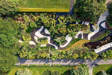
Brazil, Sítio Roberto Burle Marx
Situated west of Rio de Janeiro, the site embodies a successful project developed over more than 40 years by landscape architect and artist Roberto Burle Marx (1909-1994) to create a “living work of art” and a “landscape laboratory” using native plants and drawing on Modernist ideas. Began in 1949, the garden features the key characteristics that came to define Burle Marx’s landscape gardens and influenced the development of modern gardens internationally. The garden is characterized by sinuous forms, exuberant mass planting, architectural plant arrangements, dramatic colour contrasts, use of tropical plants, and the incorporation of elements of traditional folk culture. By the end of the 1960s, the site housed the most representative collection of Brazilian plants, alongside other rare tropical species. In the site, 3,500 cultivated species of tropical and subtropical flora grow in harmony with the native vegetation of the region, notably mangrove swamp, restinga (a distinct type of coastal tropical and subtropical moist broadleaf forest) and the Atlantic Forest. Sítio Roberto Burle Marx exhibits an ecological conception of form as a process, including social collaboration which is the basis for environmental and cultural preservation. It is the first modern tropical garden to be inscribed on the World Heritage List.
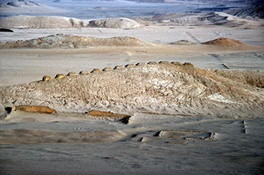
Peru, Chankillo Archaeoastronomical Complex
Chankillo Archaeoastronomical Complex is a prehistoric site (250-200 BC), located on the north-central coast of Peru, in the Casma Valley, comprising a set of constructions in a desert landscape that, together with natural features, functioned as a calendrical instrument, using the sun to define dates throughout the year. The site includes a triple-walled hilltop complex, known as the Fortified Temple, two building complexes called Observatory and Administrative Centre, a line of 13 cuboidal towers stretching along the ridge of a hill, and the Cerro Mucho Malo that complements the Thirteen Towers as a natural marker. The ceremonial centre was probably dedicated to a solar cult, and the presence of an observation point on either side of the north-south line of the Thirteen Towers allows the observation both of the solar rising and setting points throughout the whole year. The site shows great innovation by using the solar cycle and an artificial horizon to mark the solstices, the equinoxes, and every other date within the year with a precision of 1-2 days. It is thus a testimony of the culmination of a long historical evolution of astronomical practices in the Casma Valley.
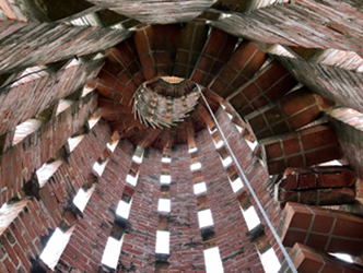
Uruguay, The work of engineer Eladio Dieste: Church of Atlántida
The Church of Atlántida with its belfry and underground baptistery is located in Estación Atlántida, 45 km away from Montevideo. Inspired by Italian paleo-Christian and medieval religious architecture, the modernistic Church complex, inaugurated in 1960, represents a novel utilization of exposed and reinforced brick. Built on rectangular plan of one single hall, the church features distinctive undulating walls supporting a similarly undulating roof, composed of a sequence of reinforced brick Gaussian vaults developed by Eladio Dieste (1917-2000). The cylindrical bell-tower, built in openwork exposed brick masonry, rises from the ground to the right of the main church facade, while the underground baptistery is located on the left side of the parvis, accessible from a triangular prismatic entrance and illuminated via a central oculus. The Church provides an eminent example of the remarkable formal and spatial achievements of modern architecture in Latin America during the second part of the 20th century, embodying the search for social equality with a spare use of resources, meeting structural imperatives to great aesthetic effect.
Chile, Settlement and Artificial Mummification of the Chinchorro Culture in the Arica and Parinacota Region
The property consists of three components: Faldeo Norte del Morro de Arica, Colón 10, both in the city of Arica, and Desembocadura de Camarones, in a rural environment some 100km further south. Together they bear testimony to a culture of marine hunter-gatherers who resided in the arid and hostile northern coast of the Atacama Desert in northernmost Chile from approximately 5450 BCE to 890 BCE. The property presents the oldest known archaeological evidence of the artificial mummification of bodies with cemeteries that contain both artificially mummified bodies and some that were preserved due to environmental conditions. Over time, the Chinchorro perfected complex mortuary practices, whereby they systematically dismembered and reassembled bodies of deceased men, women and children of the entire social spectrum to create “artificial” mummies. These mummies possess material, sculptural, and aesthetic qualities that are presumed to reflect the fundamental role of the dead in Chinchorro society. Tools made of mineral and plant materials as well as simple instruments made of bone and shells that enabled an intensive exploitation of marine resources, have been found in the property which bears a unique testimony to the complex spirituality of the Chinchorro culture.
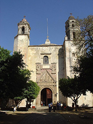
Mexico, Franciscan Ensemble of the Monastery and Cathedral of Our Lady of the Assumption of Tlaxcala [extension of “Earliest 16th-Century Monasteries on the Slopes of Popocatepetl”, inscribed in 1994]
The Franciscan Ensemble of the Monastery and Cathedral of Our Lady of the Assumption is part of the first construction programme launched 1524 for the evangelization and colonization of the northern territories of Mexico. The ensemble is one of the first five monasteries established by Franciscan, Dominican and Augustinian friars, and one of three still standing. The other two are already inscribed on the World Heritage List. The Tlaxcala ensemble of buildings provides an example of the architectural model and spatial solutions developed in response to a new cultural context, which integrated local elements to create spaces such as wide atria, and capilla posa chapels. The edifice presents two other particular features, a free-standing tower and a wooden mudéjar not found in the other monasteries already inscribed on the World Heritage List as part of the serial property. It contributes to a better understanding of the development of a new architectural model that influenced both urban development and monastic buildings until the 18th century.
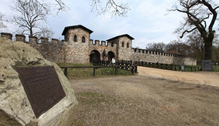
Germany / Netherlands, Frontiers of the Roman Empire – The Lower German
Limes Following the left bank of the Lower Rhine River for approximately 400 km from the Rhenish Massif in Germany to the North Sea coast in the Netherlands, the transnational property consist of 102 components from one section of the frontiers of the Roman Empire, which in the 2nd century CE, stretched across Europe, the Near East, and North Africa, over 7,500 km. The property comprises military and civilian sites and infrastructure that marked the edge of Lower Germany from the 1st to 5th centuries CE. Archaeological remains in the property include military bases, forts, fortlets, towers, temporary camps, roads, harbours, a fleet base, a canal, and an aqueduct, as well as civilian settlements, towns, cemeteries, sanctuaries, an amphitheatre, and a palace. Almost all of these archaeological remains are buried underground. Waterlogged deposits in the property have enabled a high degree of preservation of both structural and organic materials from the Roman periods of occupation and use.
Germany, ShUM Sites of Speyer, Worms and Mainz
Located in the former Imperial cathedral cities of Speyer, Worms and Mainz, in the Upper Rhine Valley, the serial site of Speyer, Worms and Mainz comprise the Speyer Jewry-Court, with the structures of the synagogue and women’s shul (Yiddish for synagogue), the archaeological vestiges of the yeshiva (religious school), the courtyard and the still intact underground mikveh (ritual bath), which has retained its high architectural and building quality. The property also comprises the Worms Synagogue Compound, with its in situ post-war reconstruction of the 12th century synagogue and 13th century women’s shul, the community hall (Rashi House), and the monumental 12th-century mikveh. The series also includes the Old Jewish Cemetery in Worms and the Old Jewish Cemetery in Mainz. The four component sites tangibly reflect the early emergence of distinctive Ashkenaz customs and the development and settlement pattern of the ShUM communities, particularly between the 11th and the 14th centuries. The buildings that constitute the property served as prototypes for later Jewish community and religious buildings as well as cemeteries in Europe. The acronym ShUM stands for the Hebrew initials of Speyer, Worms and Mainz.